The Loup Rivers Scenic Byway is a hidden gem that provides visitors with a one-of-a-kind journey through the state’s rich history, varied landscapes, and vibrant communities. It is situated in the center of Nebraska. The Sandhills, one of the biggest grass-covered dune fields in the world, and the Loup River system are both traversed by this 150-mile route that travels along Highways 11 and 91.
Where is the Loup Rivers Scenic Byway located?
The road is situated in central Nebraska, stretching across several counties, including Howard, Greeley, and Valley. The Byway begins in the town of St. Paul and continues westward through the Sandhills region, following the Loup River system, before ending in the town of Dunning.
The area offers a wealth of recreational opportunities. The Calamus Reservoir State Recreation Area, located near Burwell, is a popular destination for boating, fishing, and camping. The area is also home to the Calamus Golf Course, a challenging 9-hole course that offers stunning views of the surrounding landscape.
The map below shows where this road is located:
Enlarge the map
Information about the road:
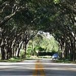
The Loup Rivers Scenic Byway is a testament to Nebraska’s natural beauty. The route offers panoramic views of the Sandhills, a region characterized by rolling hills, vast grasslands, and numerous lakes and wetlands. The Sandhills are a haven for wildlife, with species such as pronghorn antelope, white-tailed deer, and a variety of bird species, including the endangered whooping crane, making their home in this region.
The Byway also follows the Loup River system, a series of three rivers that provide a lifeline for the region’s flora and fauna. The rivers are a popular destination for canoeing, fishing, and bird watching, with numerous access points along the Byway.
History of the Loup Rivers Scenic Byway:
The road along the Loup Rivers is rich in history. The Pawnee Native American tribe once called this area home, and signs of their presence can still be seen today. For history buffs, the Pawnee Indian Museum near Genoa is a must-visit because it provides insight into the tribe’s culture and way of life.
Nebraska’s Big Rodeo, an annual event held in Burwell since 1921, is one of the historic towns that the Byway passes through. Another noteworthy stop along the way is the town of St. Paul, where renowned author and anthropologist Loren Eiseley was born.
How to get to the Loup Rivers Scenic Byway:
To access the Loup Rivers Scenic Byway, travelers can begin their journey in St. Paul, Nebraska. The town is located approximately 130 miles west of Omaha and 100 miles north of Lincoln. From St. Paul, follow Highway 11 northward, and then continue westward on Highway 91. The Byway is well-marked with signs, making navigation easy for travelers.
Another road to drive in the U.S is for example the Loveland Pass in Colorado.
You can obviously visualize how to get there on this approximative map of the drive:
Is the Loup Rivers Scenic Byway open?
The Loup Rivers Scenic Byway is open year-round, allowing travelers to experience the beauty of the region in all seasons. However, it’s essential to be aware of local weather conditions, particularly during the winter months. Indeed, snow and ice may cause temporary road closures or hazardous driving conditions. It’s recommended to check local weather forecasts and road conditions before embarking on your journey.
The Byway also provides access to the Nebraska National Forest, a unique man-made forest that offers hiking, horseback riding, and picnicking opportunities.
The Loup Rivers Scenic Byway is more than just a road; it’s a journey through Nebraska’s heartland. Whether you’re a nature lover, a history buff, or simply looking for a beautiful drive, this road offers something for everyone. So, pack your bags, hit the road, and discover the beauty and charm of Nebraska’s roads.
Picture credit: https://www.flickr.com/photos/ordsunshinepumpers / https://www.flickr.com/photos/neighborhoods/7434054368
Discover other roads around the world: click here
![]()
![]()
![]()
![]()
![]()
![]()
![]()